Charleston Flood Maps
Sea Island Builders uses state-of-the-art technology to assess and provide studies of current and future Charleston flood maps and offers flood risk management studies
The 2019 Atlantic hurricane season is officially upon us. Beginning June 1 and running until November 30, potential storms are almost always a running topic of conversation throughout the coastal Lowcountry. The City of Charleston and entire Lowcountry region have experienced drainage and flooding problems since its founding due to tidally influenced rivers and streams, close proximity to the Atlantic Ocean, and low coastal elevation. The Charleston area and entire Lowcountry has seen three flood events in the past three years alone that have exceeded the 10 year probability. Flooding and potential flood damage has become a major concern for property owners and those considering a residential construction project. Through its Risk MAP program, the Federal Emergency Management Association (FEMA) consistently releases new flood map and data, giving communities across the United States accurate and helpful data to be used to make decisions about flood risk. While these flood maps are available to the public, it can often be difficult to read and understand. Property owners or potential property owners in the the Charleston area are likely concerned with current sea level rise projections and how potential flooding may impact their home or property.
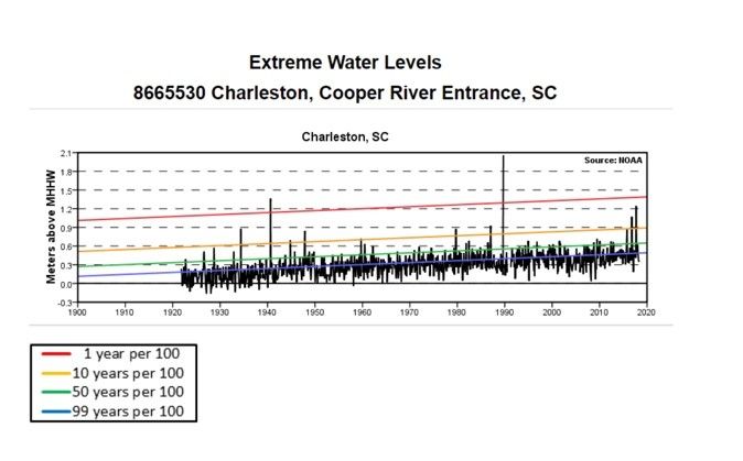
Over the past 100 years the Charleston area has seen a mean high high water (MHHW) increase of 1 foot. The MHHW is the elevation of the highest tide in a given tide cycle. There are two tide cycles in a 24 hour period. Most scientists agree that we can expect to see twice the rate of increase in the next 100 years as we have seen in the previous century.
Given the available data, it is imperative to plan ahead to properly prepare your home and property for future flood events. What does this mean for you as a homeowner or potential property owner in the Lowcountry? It is important to understand available Charleston flood maps and perform a flood risk assessment of your property or potential project site at the outset in order to properly analyze current flood conditions as well as forecast the potential effects that climate change and sea level rise projections might have for the next 25-30 years. One of the first steps in planning a project is to understand Charleston flood maps by performing a flood risk assessment of the property, in order to make an informed decision on important factors such as to where to set the house pad and what the elevation should be.This includes thinking about any accessory structures, overall site and block drainage and landscaping goals.
There are many variables unique to the Lowcountry that should be taken into consideration when planning a residential construction project. It is important to understand the Charleston flood maps and local flood zones and associated risks in order to adequately prepare for and mitigate flood loss when designing and building a home in the Charleston or nearby coastal areas. Home elevation directly impacts insurance rates. The Federal Emergency Management Agency (FEMA) is expected to release an updated Flood Insurance Rate Map which will affect homeowner's insurance rates once the preliminary data becomes effective.
When planning a residential construction project it is prudent to have a qualified professional perform a flood risk assessment before beginning the project. A few of the myriad factors that should be considered include:
1- every location is unique and potentially affected by tides (king, high and mean high high and downriver flow)
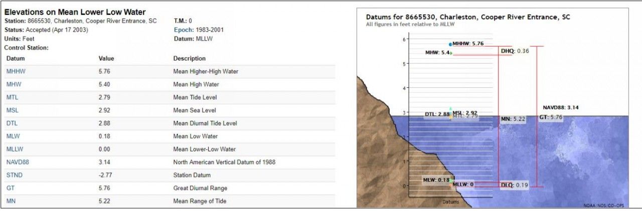
2- the MHHW datum has a different relative zero than the datum from a land survey; as such, ground topography and sea level heights are not an equal comparison point. It is important to have a professional who specializes in collecting and understanding datum from both studies, review plans in order to gain a complete and accurate picture before moving into the design phase.
3- Sea Island Builders understands Charleston flood maps and works to determine a client's goals for flood planning, including which parameters to design around. For instance, does a client want to keep king tides out of the yard or will the project be designed to withstand storm surges to a certain point? All of these goals and considerations should be discussed and planned for before initiating a project.
The volume of information and data concerning Charleston flood maps and flood forecasting and flood mitigation can be overwhelming; therefore, It is important to hire a professional to conduct a thorough flood risk assessment when planning a construction project in the Lowcountry. There are several firms that specialize in commercial and industrial flood planning but few firms exist that perform comprehensive flood risk management studies for the residential market. Sea Island Builders uses state-of-the-art technology to perform flood risk management studies to graphically illustrate various potential flood conditions to aid clients in selecting the best design for their needs. Working with a qualified design-build firm like Sea Island Builders will provide the most comprehensive and accurate information available to the residential construction market.
For more information regarding Charleston flood maps and residential flood studies, please call Sea Island Builders at 843-883-7430.


